apply for the winter 2026 citizens planning academy!
The Citizens Planning Academy is returning early in the new year with a new schedule. Learn more and apply today!

The road not taken… Delayed three years!
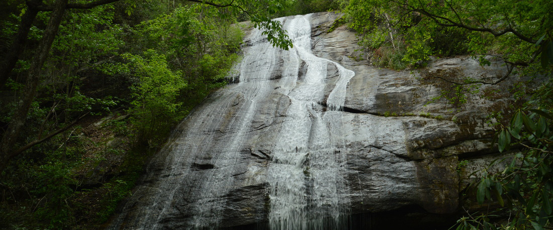
Former UF board member Emelyn Jones recently completed the trek to "one of the most elusive and remote falls in the Carolinas." In this essay, originally published in the South Carolina Department of Natural Resources' Jocassee Journal, Emelyn reflects on her experience hiking to Hilliard Falls, located off the Foothills Trail.
 In 2018, I fulfilled a goal when I hiked the 77-mile Foothills Trail with my husband, Neil, and our friend and neighbor, David Delahunty. My only regret was not taking the spur trail to Hilliard Falls, which is arguably one of the most elusive and remote falls in the Carolinas. These falls were named after Glenn Hilliard, one of the original founders of The Foothills Trail. I have worked with Glenn through our service on the Board of Upstate Forever, which deepened my desire to see this waterfall!
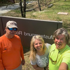
Three years later and after doing some research, I discovered that one of the trailheads to Hilliard Falls is Line Rock Gap which can be accessed via Musterground Road at Duke Energy’s Bad Creek Facility. We had been on this road a few times to hike to Lower Whitewater Falls, but never ventured as far as we needed to today. The gravel road is only open in the month of April, and from September 15 through January 2. One of my favorite resources when exploring is my “DNR Jim Timmerman Natural Resources Area at Jocassee Gorges” map. This free map can be found at many of the State Parks in this area, and is a must for anyone wanting to discover the riches of the Gorges. Pulling out my DNR map, the trailhead at Line Rock Gap was located about six miles from Bad Creek, and on a perfectly sunny April day, the tenacious trio of Neil, David and Em set out for a memorable venture. We packed lots of water and fruit, and set off to Musterground Road in Neil’s Jeep Gladiator… and yes, you do need a 4x4 high clearance vehicle (and a keen sense of adventure!) for this quest. It is not for the faint of heart!
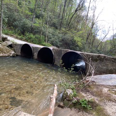 What a wonderful gift it was to be heading to our destination with no time limits! As we drove past Bad Creek Access, we had beautiful views off to our right of Lake Jocassee, the purest lake in South Carolina. There were “many mini” waterfalls along the way that tempted us to stop and savor. My favorite stop was about five miles in — right before we crossed The Thompson River. We strolled along a beautiful sandy bank to get a great view of the extremely “unique” bridge over the Thompson built from old boilers, drainpipes, or something of their likeness!
Crossing Whitewater and Thompson Rivers was a thrill that provided first-class views. These are two of the four mountainous rivers that feed Lake Jocassee with their beautiful, cold, clear water, providing many of us with our drinking water. If you believe, like I do, that water is our most valuable resource on the planet, this is a glorious sight!
Six miles deep into the rugged Jocassee Gorges, we pulled over to the left at Line Rock Gap and found the red gate at the trailhead. Watch carefully for the gate as it is easily missed! Here is where we set out on foot to hike the .4 mile spur trail to The Foothills Trail. Connecting with the trail felt familiar as we turned right and headed towards Horsepasture River.
As my mother says, nature is the best gardener! We especially enjoyed the blooms of the wild dogwoods and mini purple irises as we hiked. About two miles in, we found the sign pointing us to our final destination — the 50-foot spectacular waterfall that is Hilliard Falls! I was struck by the solitude and peacefulness of the pools beneath the falls that flow into Bearcamp Creek. The water temperature was a cool 58 degrees (yes, I carry a water thermometer in my backpack!) which made me think how refreshing it would feel in the heat of the summer. Mission accomplished! Was it worth the wait? Absolutely! And just like that, it was time to head back.
On the hike out, we ran into some thru-hikers from North Carolina looking for some guidance on campsites. There is such camaraderie on the trail and I was happy for the five-minute rest as we stopped to chat with them. A gentle rain cooled us off, reminding me that we were in the only temperate rain forest east of the Rockies. In all, the round-trip hike was 4.4 miles. There was a good bit of elevation but nothing that our easy and steady pace couldn’t handle.
Reflecting on the day, I continue to be thankful for the visionaries who preserved this area and who continue to work tirelessly to protect this special, special place in our state and our country. There is much work to be done, and the time is now! Please get out and enjoy the outdoors — and let me tag along!
The Jocassee Journal is SCDNR's twice-yearly publication about the wild and remarkable Jocassee Gorges. Click here to read a PDF of the Spring/Summer 2021 issue.
Greenville, SC
507 Pettigru Street
Greenville, SC 29601
Spartanburg, SC
900 S. Pine St, Ste 1B
Spartanburg, SC 29302
'%3e%3cg id='Final-Copy-2_2_' transform='translate(1275.000000, 200.000000)'%3e%3cpath class='st0' d='M7.4,12.8h6.8l3.1-11.6H7.4C4.2,1.2,1.6,3.8,1.6,7S4.2,12.8,7.4,12.8z'/%3e%3c/g%3e%3c/g%3e%3c/g%3e%3cg id='final---dec.11-2020'%3e%3cg id='_x30_208-our-toggle' transform='translate(-1275.000000, -200.000000)'%3e%3cg id='Final-Copy-2' transform='translate(1275.000000, 200.000000)'%3e%3cpath class='st1' d='M22.6,0H7.4c-3.9,0-7,3.1-7,7s3.1,7,7,7h15.2c3.9,0,7-3.1,7-7S26.4,0,22.6,0z M1.6,7c0-3.2,2.6-5.8,5.8-5.8 h9.9l-3.1,11.6H7.4C4.2,12.8,1.6,10.2,1.6,7z'/%3e%3cpath id='x' class='st2' d='M24.6,4c0.2,0.2,0.2,0.6,0,0.8l0,0L22.5,7l2.2,2.2c0.2,0.2,0.2,0.6,0,0.8c-0.2,0.2-0.6,0.2-0.8,0 l0,0l-2.2-2.2L19.5,10c-0.2,0.2-0.6,0.2-0.8,0c-0.2-0.2-0.2-0.6,0-0.8l0,0L20.8,7l-2.2-2.2c-0.2-0.2-0.2-0.6,0-0.8 c0.2-0.2,0.6-0.2,0.8,0l0,0l2.2,2.2L23.8,4C24,3.8,24.4,3.8,24.6,4z'/%3e%3cpath id='y' class='st3' d='M12.7,4.1c0.2,0.2,0.3,0.6,0.1,0.8l0,0L8.6,9.8C8.5,9.9,8.4,10,8.3,10c-0.2,0.1-0.5,0.1-0.7-0.1l0,0 L5.4,7.7c-0.2-0.2-0.2-0.6,0-0.8c0.2-0.2,0.6-0.2,0.8,0l0,0L8,8.6l3.8-4.5C12,3.9,12.4,3.9,12.7,4.1z'/%3e%3c/g%3e%3c/g%3e%3c/g%3e%3c/g%3e%3c/svg%3e) Your Privacy Choices
Your Privacy Choices© 2025 Upstate Forever. All Rights Reserved|
Site by ALINE, A Marketing Company